Pyrocumulonimbus clouds are fire-generated thunderstorms that form when intense wildfires create powerful updrafts of hot air, vapor, and smoke. This summer, France and Spain have witnessed these massive storm clouds first-hand, and scientists are warning that they are altering the atmosphere in ways we are only beginning to understand.
What Are Pyrocumulonimbus Clouds?
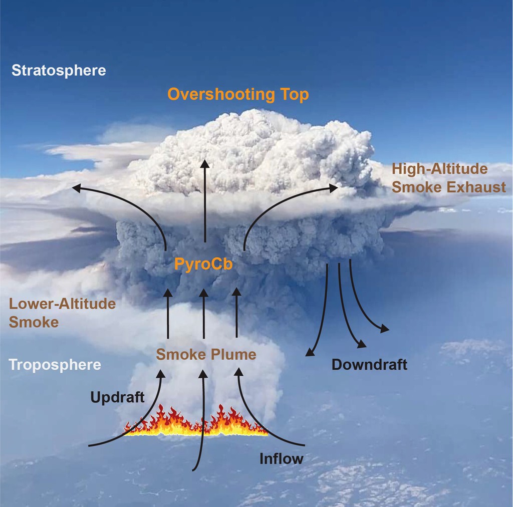
According to the American Meteorological Society's official glossary, pyrocumulonimbus clouds are essentially storms generated by fires. When a wildfire becomes massive and intense enough, it produces updrafts of extremely hot air. This air carries water vapor, ash, and smoke particles high into the atmosphere.
Find Original Home Decor sparking conversation at Grand Goldman Shop.

As the vapor reaches colder layers, it condenses into a huge convective cloud. The result is a pyrocumulonimbus—a storm cloud that looks like a thunderhead but is born from fire rather than the natural climate cycle. These clouds can produce lightning, strong winds, and even precipitation, all while the fire below continues to burn.
Why This Summer's Fires Are Different
This summer's wildfire season has been historic in magnitude, particularly in France and Spain. The images have been extreme and unprecedented: towering storm clouds that seem straight out of a disaster movie. But these are not simple smoke plumes—they are self-sustaining weather systems.
The key difference is scale. When fires burn hot enough and over large enough areas, they create their own weather. The pyrocumulonimbus phenomenon is no longer an anecdotal rarity; it is becoming a recurring feature of major fire events. Scientists are concerned because these clouds can inject smoke and pollutants into the stratosphere, where they linger for months and affect global climate patterns.
How Pyrocumulonimbus Clouds Form
The formation process is straightforward but requires extreme conditions. First, a wildfire must generate intense heat, creating a strong updraft. Second, there must be enough moisture in the air—either from the environment or from the combustion process itself—to condense into clouds. Third, the updraft must be powerful enough to push the cloud high into the atmosphere, where it can develop into a full thunderstorm.
Once formed, these clouds can produce lightning, which can ignite new fires, creating a dangerous feedback loop. They can also generate strong downdrafts that spread embers and fan the flames, making firefighting efforts even more challenging.
Volcanic Impact: A New Atmospheric Force
The impact of pyrocumulonimbus clouds has been compared to volcanic eruptions. Like volcanoes, these fire storms can inject large amounts of smoke and ash into the stratosphere. This can affect atmospheric chemistry, reduce sunlight reaching the surface, and even influence weather patterns far from the fire itself.
Researchers are only beginning to quantify these effects. The pyrocumulonimbus phenomenon represents a new frontier in climate science, one that blurs the line between natural disasters and human-induced climate change. As wildfires become more frequent and intense due to global warming, these fire-generated storms are likely to become more common. The background to this story is set out in What Are Fire Clouds and How Do They Worsen Wildfires in Europe?. A related thread runs through Fire clouds explained: How pyrocumulonimbus worsen Europe. Earlier coverage in Climate Crisis Supercharges Europe's Wildfire Weather, Study shows how the argument developed.
Key Takeaways
- Pyrocumulonimbus clouds are thunderstorms created by extreme wildfires, not by normal weather patterns.
- They form when intense heat generates powerful updrafts that carry moisture and smoke high into the atmosphere.
- These clouds can produce lightning, strong winds, and even rain, while the fire below continues to burn.
- They can inject smoke into the stratosphere, affecting global climate and air quality.
- This summer's fires in France and Spain have provided striking examples of this phenomenon.
Comparing Pyrocumulonimbus to Other Atmospheric Events
| Feature | Pyrocumulonimbus | Regular Thunderstorm | Volcanic Eruption |
|---|---|---|---|
| Primary trigger | Wildfire heat | Atmospheric instability | Magma and gases |
| Cloud height | Up to stratosphere | Troposphere | Up to stratosphere |
| Lightning | Yes | Yes | Rare |
| Smoke injection | High | Low | High |
| Frequency | Increasing with wildfires | Common | Rare |
What to Watch Next
As fire seasons lengthen and intensify, the role of pyrocumulonimbus clouds will become more critical. Scientists are calling for better monitoring and modeling of these events to understand their full impact on air quality, climate, and fire behavior. For residents in fire-prone regions like France and Spain, these clouds are a visible sign of the growing power of wildfires. A closer look at the same subject appears in Climate Crisis Supercharges Europe's Wildfire Weather Risk. Anyone following the wider picture can start with Climate Crisis Supercharges Europe's Wildfire Weather. The same theme surfaces in California Wildfire Risk Rises as Extreme Weather Intensifies, which takes a different angle.
The coming years will likely bring more research and perhaps new policies aimed at mitigating the conditions that lead to such extreme fires. Understanding pyrocumulonimbus dynamics is a step toward better preparedness and resilience. Context on how this played out before sits in Extreme Weather Summer 2025: Wildfires and Floods Explained. A companion piece, England vs Argentina Rivalry: Football History and Intense Matche, approaches the same subject from another angle.
FAQ
What exactly is a pyrocumulonimbus cloud?
A pyrocumulonimbus cloud is a thunderstorm generated by a wildfire. It forms when intense heat creates a strong updraft that carries moisture and smoke high into the atmosphere, where it condenses into a massive convective cloud capable of producing lightning and strong winds.
Why are these clouds compared to volcanic eruptions?
Like volcanic eruptions, pyrocumulonimbus clouds can inject large amounts of smoke and ash into the stratosphere. This can affect atmospheric chemistry, reduce sunlight, and influence weather patterns on a global scale.
Are pyrocumulonimbus clouds becoming more common?
Yes, as wildfires become more frequent and intense due to climate change, the conditions that lead to pyrocumulonimbus formation are occurring more often. This summer's fires in France and Spain are prime examples.
What risks do these clouds pose?
They can produce lightning that ignites new fires, strong downdrafts that spread embers, and smoke injection into the stratosphere that affects air quality and climate. They also make firefighting more dangerous and complex.
Browse the Shop
 Acacia frida deluxe solid wood bed frame |
Bedroom bench |
Bed chest drawers |
Lingerie dresser |
Frame base |
Mirror with jewelry storage |
30 Bathroom Vanity |
Memory foam queen mattress |
Mattresses for back pain |
Nightstand set of 2 |
Grand Goldman Shop |
Civil Lawyer
Deutschland Trikot WM 2026